Live camera
Seto Inland Sea from Mount Washu live camera
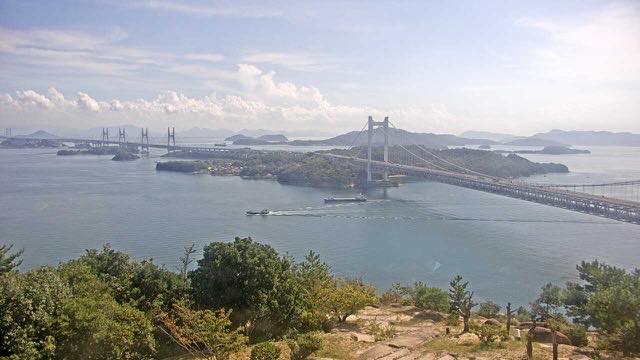
A lookout known for its scatter of islands. The Great Seto Bridge overlaps the island silhouettes, and evening backlight sets the water shining.
 Sample August 2026
What you are looking at
A view down from a lookout over a sea dotted with islands. The girders of the bridge and the island silhouettes overlap, and that is what gives the frame its depth.
There are so many islands in this sea because water came into what had been hill country and only the high ground was left. So the arrangement of the islands reproduces the arrangement of the ridges before they were flooded. The bridge you can see from here uses those islands as footings to join Honshu and Shikoku — the islands standing in a line is exactly what made bridging possible.
Setonaikai National Park, which takes in this lookout, was designated in 1934 as one of Japan’s first three national parks. The Great Seto Bridge in view opened in 1988: 9,368 metres long, built on two decks, road above and railway below.
The hill is only 133 metres high. Its name is said to come from its shape, like an eagle with its wings spread, and the hill itself is a nationally designated place of scenic beauty. Shimotsui, below, was once the port town where you took a boat to Shikoku, and a railway, the Shimotsui Dentetsu, ran along much the same line as the bridge does now. That railway closed completely in 1991. Exactly as much as the bridge brought the two shores together, something else went out of this frame.
From spring into early summer haze settles and the far islands blur. To see the silhouettes layered one behind another, come in autumn or winter when the air is clear.
Evening is the hour that feels most like the Inland Sea. The view faces west to southwest, so around sunset the water lights up and the islands cut out black. Updates come once an hour.
About this camera
| Place | Kurashiki, Okayama |
| Format | Still, hourly |
| Time zone | Asia/Tokyo (UTC+9) |
| Category | Sea · Nature |
| Operator | Ministry of the Environment — Internet Nature Institute |
| Terms of use | PDL 1.0 |
The operator's own page
The footage belongs to each agency. This site is an unofficial guide, and each sample frame was copied once per camera under that agency's terms of use.
Cameras nearby
- Asahi River at the prefectural officeOkayamaLive video
- Asahi River, Shintsurumi BridgeOkayamaLive video
- Hyakken floodway gateOkayamaLive video
- Takahashi River, Sakazu weirOkayamaLive video
- Oda River, upper weirOkayamaLive video
- Oda River, lower cameraOkayamaLive video
- Yoshii River, lower gaugeOkayamaLive video
- Yoshii River, below the weirOkayamaLive video