Live camera
Raoul Island live camera — Kermadec Islands
An uninhabited volcanic island about 1,000 km north of the mainland. The camera is there so it can be watched from a distance.
 Sample August 2026
What you are looking at
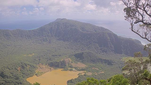
A GeoNet camera showing Raoul Island, roughly a thousand kilometres north of the New Zealand mainland.
It is the largest island in the Kermadecs, and nobody lives there now. Staff were once stationed on it, but in 2006 a sudden eruption near the crater killed a worker who was out on the ground. Since then the island has been watched by unmanned cameras and instruments alone. This frame is that decision made visible: monitor the volcano, don't put people on it.
Sitting in the middle of a subtropical ocean, the island is heavily vegetated, and the scars of eruption sit in the same frame as the forest. It is also known as a seabird breeding ground and is a protected nature reserve.
There is a reason the forest is as thick as it is. Rats and cats brought in by people had multiplied and were eating the native birds, and a programme to remove them ran for ten years, finishing in 2004. At the time it was the largest multi-species eradication anywhere in the world. Seabirds came back afterwards and seedlings started getting away, so the green in this frame is partly the result of that work. The island is one of a line of volcanoes just west of the Kermadec Trench, standing over the boundary where the Pacific plate goes down.
New Zealand runs three to four hours ahead of Japan, so opening it early in the Japanese morning corresponds to local morning or midday. The still refreshes every ten minutes, and nothing shows after dark.
About this camera
| Place | Kermadec Islands |
| Format | Still, every 10 min |
| Time zone | Pacific/Auckland (UTC+12, DST UTC+13) |
| Category | Volcano |
| Operator | GeoNet New Zealand |
| Terms of use | CC BY 3.0 NZ |
The operator's own page
The footage belongs to each agency. This site is an unofficial guide, and each sample frame was copied once per camera under that agency's terms of use.
Cameras nearby
- Mount Ruapehu, eastNorth IslandStill, every 10 min
- Mount Ruapehu, southNorth IslandStill, every 10 min
- Te Maari craters, Mount TongariroNorth IslandStill, every 10 min
- Mount NgauruhoeNorth IslandStill, every 10 min
- Whakatane coastNorth IslandStill, every 10 min
- Ngauruhoe and TongariroNorth IslandStill, every 10 min
- Te Kaha coastNorth IslandStill, every 10 min
- Mount TongariroNorth IslandStill, every 10 min