Live camera
Mount Bandai live camera — Fukushima
The 1888 eruption collapsed the north side, and the debris dammed the valleys into the Urabandai lakes. Front and back look like two different mountains.
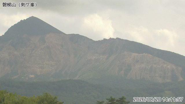 Sample August 2026
What you are looking at
Mount Bandai, under continuous watch by the Japan Meteorological Agency. It is visible from anywhere in the Aizu basin, and the whole massif fits in the frame.
It stands 1,816 metres. In the 1888 eruption the northern peak, Ko-Bandai, collapsed outright; the debris avalanche buried settlements at the foot and took many lives. The rivers it dammed became the lakes of Urabandai — Lake Hibara and the Goshiki ponds among them. The tidy cone you see from the south and the torn-out wall you see from the north are hard to believe are the same mountain.
The 1888 eruption is recorded as 15 to 20 explosions repeated in a short space of time. The sound was heard 50 to 100 kilometres away and the ash reached the Pacific coast. The crater it left is a U-shape open to the north, about 2.2 kilometres east to west and two kilometres north to south. Only four phreatic eruptions have been found here in the last 5,000 years, at intervals of 1,100 to 1,700 years.
The main event is the autumn colour from late October into early November, when the broadleaf trees on the slopes turn. Winter is deep-snow country here and the frame reduces to little more than white and black. Around May, snow still lies on the summit while the foot is coming into leaf, so the picture splits into two seasons.
The aspect avoids harsh backlight morning and evening, so mornings show the relief best. The still refreshes every two minutes.
About this camera
| Place | Fukushima |
| Format | Still, every 2 min |
| Time zone | Asia/Tokyo (UTC+9) |
| Category | Volcano · Nature |
| Operator | Japan Meteorological Agency — volcano surveillance cameras |
| Terms of use | PDL 1.0 |
The operator's own page
The footage belongs to each agency. This site is an unofficial guide, and each sample frame was copied once per camera under that agency's terms of use.
Cameras nearby
- Lake Renge and Mount BandaiKitashiobara, FukushimaStill, hourly
- Mount AzumaFukushima / Yamagata borderStill, every 2 min
- Mount AdataraFukushimaStill, every 2 min