Live camera
Sasame Bridge live camera — Toda, Saitama
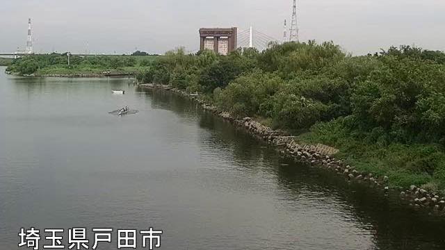
28.8 km from the river mouth. Where National Route 17 crosses the Arakawa, seen from the Toda side. From here down, the floodplain stays wide the whole way.
 Sample August 2026
What you are looking at
The point where National Route 17, the Shin-Omiya Bypass, crosses the Arakawa, seen from the Toda side. Of the Arakawa cameras on this site, this is the furthest upstream.
The "28.8k" burned into the frame is the distance from the river mouth. Ministry of Land, Infrastructure and Transport river cameras stamp the distance marker onto the image, so any single frame can be placed just by looking at it.
On the Toda side, where the camera stands, a rowing course occupies an old channel of the Arakawa left stranded when the river was straightened. It was the rowing venue for the 1964 Tokyo Olympics, and it survives as a long, still strip of water with no current.
The flood plain below this bridge stays wide all the way to the sea. The low ground that normally looks like sports fields and paths is space deliberately left for the river to use when the water rises, and in heavy rain it goes under from the bottom up. You do not need to read a gauge — how far the water has come is legible from what is submerged.
The work that straightened the river was begun after the great flood of 1910. To split the water short of the built up area and drop it into the sea, a channel of about twenty-two kilometres was dug from Iwabuchi to the mouth, and it was opened in 1930. What is called the Arakawa here is that cut channel, and the lower course of the original Arakawa now goes by the name Sumidagawa.
The still refreshes every minute. The rougher the day, the darker the frame and the more raindrops smear the lens. Decisions about evacuating belong to your local authority.
About this camera
| Place | Toda, Saitama |
| Format | Still, every minute |
| Time zone | Asia/Tokyo (UTC+9) |
| Category | River |
| Operator | MLIT Arakawa Downstream River Office |
| Terms of use | PDL 1.0 |
The operator's own page
The footage belongs to each agency. This site is an unofficial guide, and each sample frame was copied once per camera under that agency's terms of use.
Cameras nearby
- Shin-Arakawa BridgeKawaguchi, SaitamaStill, every minute
- Ara and Iruma riversSaitama–TokyoLive video, rotating