Live camera
Oyodo River live camera — Miyazaki
It meanders widely through central Miyazaki to the Hyuga Sea. The city presses against the levees, so town lights sit alongside the water.
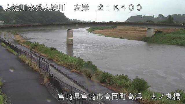 Sample August 2026
Watch it here
Play the stream
Nothing is requested from YouTube until you press it. What plays is the operator's own stream; this site neither records nor rebroadcasts it.
What you are looking at
The basin of this river is covered by a whitish plateau built up from volcanic ejecta. It is soil that lets water through easily and collapses easily. That the river meanders so much, and that turbidity appears readily after rain, are both because it runs over easily eroded ground: the nature of the ground has become the shape of the river.
The stretch through the city is long, so when the level rises the distance to people's lives looks short. Buildings line the embankment, and at night the town's lights and the water are in the same frame.
The source is not in Miyazaki but on the Kagoshima side, at Mount Nakadake in Soo. The river flows north, comes out into the Miyakonojo basin, then takes in one tributary after another fed by groundwater welling from the Kirishima range, passes a narrow stretch, turns east, joins its largest tributary the Honjo and enters the Miyazaki plain. It runs 107 kilometres over 2,230 square kilometres with 600,000 people.
Annual rainfall in the basin is about 2,600 millimetres, reaching 2,900 to 3,000 in the Wanitsuka and Hyuga ranges near the source. The rain concentrates in the June-July rainy season and the August-September typhoons, and almost all of the great floods of the past came from typhoons. The floods of September 1954, August 1982 and September 2005 each prompted a review of the design discharge.
Typhoons in August and September move it most. Even without a typhoon, heavy rain falls when humid air comes up from the south. Leave evacuation decisions to the local authorities.
About this camera
| Place | Miyazaki |
| Format | Live video, rotating |
| Time zone | Asia/Tokyo (UTC+9) |
| Category | River |
| Operator | MLIT river live streams |
| Terms of use | Government Standard Terms 2.0 |
The operator's own page
The footage belongs to each agency. This site is an unofficial guide, and each sample frame was copied once per camera under that agency's terms of use.
Cameras nearby
- Kirishima Range from Ebino PlateauEbino, MiyazakiStill, hourly
- Gokase RiverNobeoka, MiyazakiLive video, rotating
- Komaru RiverTakanabe, MiyazakiLive video, rotating
- Shinmoedake, KirishimaMiyazaki / Kagoshima borderStill, every 2 min