Live camera
Midori River live camera — Uto, Kumamoto
It runs south of the Kumamoto plain to the Ariake Sea. Broad tidal flats at the mouth make the river look visibly narrower at low tide.
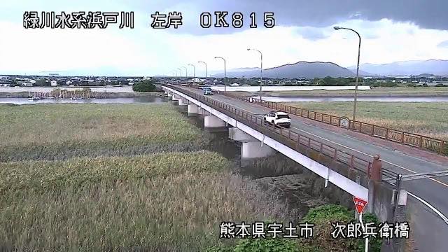 Sample August 2026
Watch it here
Play the stream
Nothing is requested from YouTube until you press it. What plays is the operator's own stream; this site neither records nor rebroadcasts it.
What you are looking at
It looks narrower less because the water drops than because the bed appears. The mouth of this river faces the sea with the largest tidal range in Japan, and when the tide goes out a broad mud bottom is exposed. The tidal flats on the Ariake side are the largest in the country, and their edge is at this river's mouth.
On a calm day the tide times are the interesting way to watch. Look up the tide, open it twice six hours apart, and the width and the colour of the water have both changed — pictures that do not look like the same place.
The source is Mount Sanpo in Yamato, Kamimashiki, at 1,578 metres. The channel is 76 kilometres and water gathers from 1,100 square kilometres. Some 540,000 people live in the basin; the southern half of the Kumamoto plain belongs to this river's watershed. It takes in the Kase and the Hamado before entering the Ariake Sea, so near the mouth there is more than one way out for the water.
Here too most large floods come from the rainy-season front of June and July. The highest level in recent years came in 2007, when the gauge at Nakakabashi on the middle course set a record. The floods of 1982 and 1988 were also large. Three rivers meet in the lower reaches, so the stretch near the mouth cannot be read from the main channel's level alone.
Rain moves it at the end of the rainy season in June and July, and in typhoons. Rain falling upstream takes time to come down. Leave evacuation decisions to the local authorities.
About this camera
| Place | Uto, Kumamoto |
| Format | Live video, rotating |
| Time zone | Asia/Tokyo (UTC+9) |
| Category | River |
| Operator | MLIT river live streams |
| Terms of use | Government Standard Terms 2.0 |
The operator's own page
The footage belongs to each agency. This site is an unofficial guide, and each sample frame was copied once per camera under that agency's terms of use.
Cameras nearby
- Kuma RiverHitoyoshi, KumamotoLive video, rotating
- Mount Nakadake and Kusasenri, AsoAso, KumamotoLive video
- Kusasenri, Mount AsoAso, KumamotoStill, every 2 min
- Kikuchi RiverTamana, KumamotoLive video, rotating
- Shira RiverKumamotoLive video, rotating
- Mount Nekodake from Minami-AsoMinami-Aso, KumamotoStill, hourly