Live camera
Shira River live camera — Kumamoto
From the Aso caldera through central Kumamoto. Carrying volcanic ash, the water takes on a distinctive murk when it rises.
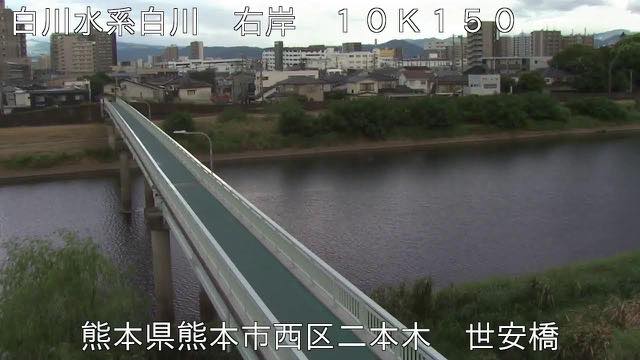 Sample August 2026
Watch it here
Play the stream
Nothing is requested from YouTube until you press it. What plays is the operator's own stream; this site neither records nor rebroadcasts it.
What you are looking at
The colour of the turbidity is different because this river comes out of the inside of a volcano. What it carries is fine soil containing Aso's ash, a different colour from ordinary brown murk. Once your eye is used to it, the colour alone tells you the river is up. Open it the day after rain has fallen on Aso and the city stretch alone can be a different colour.
This river also bears on Kumamoto's water itself. Water held in the paddies of its middle reaches soaks down and feeds the groundwater the city's supply depends on. The river on the surface and the water underground are connected.
The source is Mount Neko, one of the central cones of Aso. The river comes down the southern valley of the caldera, joins the Kurokawa from the northern valley at Tateno, and heads west across the lava plateau. The channel is 74 kilometres and the basin 480 square kilometres. The basin is shaped something like a funnel, and about eighty per cent of it is the upstream Aso country. It is a shape that collects rain upstream.
That rain falling on Aso comes out in a city shows directly in the disaster record. The flood of June 1953 left 422 dead or missing in Kumamoto and Aso and inundated over 31,000 houses. In the northern Kyushu downpour of July 2012 the reference gauge at Yotsugi Bridge recorded its highest level ever. Even with clear skies over the city, the level rises if it is raining upstream.
The headwaters are in the mountains, so the level rises even when no rain is falling on the city. Leave evacuation decisions to the local authorities.
About this camera
| Place | Kumamoto |
| Format | Live video, rotating |
| Time zone | Asia/Tokyo (UTC+9) |
| Category | River |
| Operator | MLIT river live streams |
| Terms of use | Government Standard Terms 2.0 |
The operator's own page
The footage belongs to each agency. This site is an unofficial guide, and each sample frame was copied once per camera under that agency's terms of use.
Cameras nearby
- Midori RiverUto, KumamotoLive video, rotating
- Kuma RiverHitoyoshi, KumamotoLive video, rotating
- Mount Nakadake and Kusasenri, AsoAso, KumamotoLive video
- Kusasenri, Mount AsoAso, KumamotoStill, every 2 min
- Kikuchi RiverTamana, KumamotoLive video, rotating
- Mount Nekodake from Minami-AsoMinami-Aso, KumamotoStill, hourly