Live camera
Mauna Loa live camera — Hawaii Island
One of the largest shield volcanoes on Earth by volume. Its slope is so gradual that on screen it barely reads as a mountain at all.
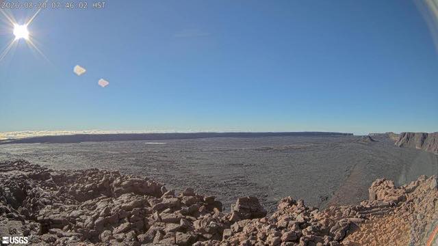 Sample August 2026
What you are looking at
A camera on Mauna Loa, on Hawaii Island, published by the United States Geological Survey.
By volume it is among the largest shield volcanoes on Earth. Thin, runny lava spread out in wide sheets to build it, which leaves the slope extremely gentle. That is why it does not read as a mountain-shaped triangle in frame — it looks more like the horizon lifting slightly. What you are seeing is not small; it is too large to have a shape that fits in a picture.
This mountain is not finished. In 2022 it erupted for the first time in about 38 years.
Hawaii runs 19 hours behind Japan. To catch a still camera in daylight you open it between about 1am and 1pm Japan time — the Japanese morning is exactly the Hawaiian midday.
On its northern slope sits an observatory that has been measuring atmospheric carbon dioxide since 1958. The site was chosen for its height and its distance from any continent, with no local sources of dirty air around it. That familiar graph of concentrations climbing year by year is built from readings taken here. The 2022 eruption cut the power line and the access road with lava and interrupted the record. Volcano monitoring and climate monitoring sit side by side on the same mountain.
Being tropical, the seasons change little; what decides the picture is volcanic activity itself.
About this camera
| Place | Hawaii Island |
| Format | Still image |
| Time zone | Pacific/Honolulu (UTC-10) |
| Category | Volcano |
| Operator | U.S. Geological Survey |
| Terms of use | U.S. government work |
The operator's own page
The footage belongs to each agency. This site is an unofficial guide, and each sample frame was copied once per camera under that agency's terms of use.
Cameras nearby
- Mount RedoubtAlaskaStill image
- Mount AniakchakAlaskaStill image
- Mount PavlofAlaskaStill image
- Mount MakushinAlaskaStill image
- Mount KanagaAlaskaStill image
- Bald eagle nestWest VirginiaLive video
- Mammoth Hot SpringsWyomingStill image
- Electric PeakWyomingStill image