Live camera
Below Metropolitan Expressway Route 7 live camera
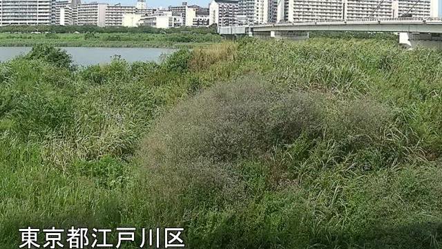
4.3 km from the mouth, downstream of where Route 7 crosses. The near bank is high floodplain thick with reeds.
 Sample August 2026
What you are looking at
Looking downstream from where the Metropolitan Expressway Komatsugawa Line, Route 7, crosses the Arakawa. 4.3 kilometres from the river mouth.
The foreground is high-water terrace thick with reeds. This close to the mouth the flood plain looks less like a sports ground and more like a marsh, and the height of the reeds becomes a way to read the water level. When the river rises, those reeds go under from the base up.
Along this stretch the Arakawa is a floodway dug by people, built to send floods out to sea instead of through the city. The straight wide channel and the high levees are that purpose made physical.
On the right bank near here, a lock joins the Arakawa to the rivers inside the levee. The land behind the levee has subsided below sea level, leaving a difference of about three metres, so boats enter a chamber and are raised or lowered before passing through. It opened in 2005, and sightseeing boats use it regularly.
Where the reeds are thick, birds have cover, so on quiet mornings there are often birds out at the waterline.
The still refreshes every minute. The river runs north to south, so the surface blows out white by day and the far bank reads best in the low light of morning and evening. At night only the expressway lights remain.
About this camera
| Place | Edogawa, Tokyo |
| Format | Still, every minute |
| Time zone | Asia/Tokyo (UTC+9) |
| Category | River |
| Operator | MLIT Arakawa Downstream River Office |
| Terms of use | PDL 1.0 |
The operator's own page
The footage belongs to each agency. This site is an unofficial guide, and each sample frame was copied once per camera under that agency's terms of use.
Cameras nearby
- Komatsugawa emergency wharfEdogawa, TokyoStill, every minute
- Shinsuna emergency wharfKoto, TokyoStill, every minute
- Shinjuku Station EastShinjuku, TokyoLive video
- Izu OshimaOshima, TokyoStill, every 2 min
- NiijimaNiijima, TokyoStill, every 2 min
- KozushimaKozushima, TokyoStill, every 2 min
- MiyakejimaMiyake, TokyoStill, every 2 min
- HachijojimaHachijo, TokyoStill, every 2 min